The Zoning Code (Title 17 of the Metro Code of Ordinances) is focused on how properties interact with their surrounding neighborhoods to promote and support things like quality of life, public safety, and a better built environment. The Metro Building and Construction Ordinance (Title 16 of the Metro Code of Ordinances) is adopted based on nationally designed standards from building officials across the country focused on standards for construction with the primary concern of protecting occupants. In other words, the Zoning Code tells you what you can build and operate on a piece of property, while the Building Code says how you can build.
Understanding the Zoning Code is important for individuals or businesses looking to sell, purchase, build, or conduct business on a parcel of property. Most property owners (or prospective buyers) can understand their property rights and restrictions by utilizing online tools provided by Metro to share information about properties.
The first step in the process should be to use the Metro Planning Department’s Parcel Viewer This online mapping tool contains nearly all of the information about a property or parcel that is collected by various Metro Departments such as the Property Assessor, Register of Deeds, Planning Department, Metro Codes and others.
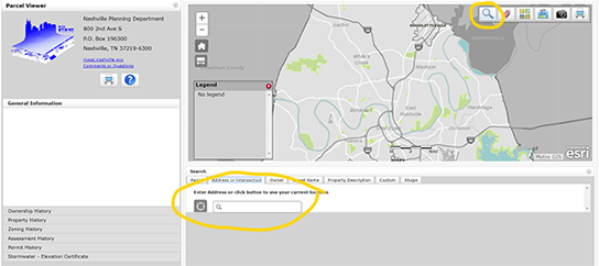
Using Parcel Viewer, search for the property you are wanting to lookup by clicking on the magnifier glass at the top right corner of the screen. Enter the address, parcel number, or owner information in the screen below (see figure below).

Once you’ve found the property you are looking for, you can learn more about that property in the bar on the left.

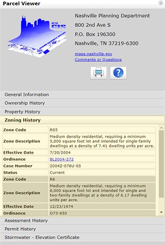
There could be multiple entries on a property, but for the purposes of new construction, you want to look at zoning codes with a status of “Current.” Inactive zoning codes may be useful for the purpose of understanding grandfathering rights of a property on a parcel.
Many properties in Nashville will only have one zoning code current and applicable to their property. At that point, the land use table and bulk district regulations to understand permitted uses, lot requirements, setbacks and more on the property.
In the example given, the property at 141 Elmhurst Ave is zoned RS5, which encourages medium density residential properties, with a minimum of 5,000 square feet per lot intended for single-family dwellings.
The District Land Use table (Metro Code 17.08.030) shows that this parcel is zoned residential and is not approved for most commercial activity.
The District Bulk Tables (Metro Code 17.12.020) show that this parcel is approved for a single-family dwelling with a maximum height of 3 stories, a maximum of 50% building coverage on the lot, a minimum 20 foot rear setback, and 5 foot side setback. Street setbacks for single and two-family structures are listed in Metro Code 17.12.030, which shows a minimum 20 foot setback on minor-local and local streets, and a 40 foot setback on all other streets. If there is an established development pattern, Metro Code 17.12.030(C) applies.
When looking up setback or height restrictions, be sure to see whether your property is in an overlay district. Examples include a Neighborhood Conservation Zoning Overlay (NCZO), Historic Preservation Zoning Overlay (HPZO), Urban Design Overlay (UDO), and the Urban Zoning Overlay (UZO). These overlays are in addition to the base zoning of the property. If that is the case, then the property could have restrictions or rights granted to the property that don’t exist in the base zoning.
In the event that a property is zoned Specific Plan (SP), then as the name suggests, there is a specific plan for the property that should be carefully read to understand the rights and permitted uses on the property. In some cases, it could mean a minor change to base zoning, in others, the property may be unique and unlike any others in the surrounding neighborhood. An SP must be considered and adopted by the Metro Council and Planning Commission before going into effect.

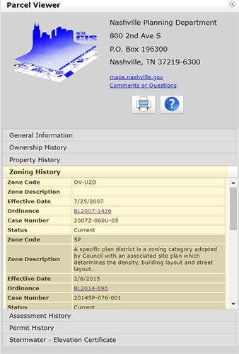
This figure is an example of property with a Specific Plan located at 1219 Stockell Street. The property sits in the Urban Zoning Overlay and is zoned "SP". In order to understand the Specific Plan, you must click on the Ordinance to find the plan. In this case, it is BL2014-896, signed into law in 2015 that changed the zoning for much of the Cleveland Park and McFerrin Park neighborhoods to allow for detached-accessory dwelling units (DADUs). The first note in the SP states that the “purpose of this SP is to permit detached accessory dwelling units and all standards of RS5 for primary and accessory structures that are not detached accessory dwelling units.”
This means that unless you are seeking to build a detached-accessory dwelling unit on the property, then the base zoning code for RS5 applies. For questions regarding SP zoning, please contact the Metro Planning Department. However, this property is also zoned UZO, which means certain restrictions and differences exist. The UZO was created in 2000 and was designed to protect the character of portions of the city that were developed in the urban core prior to the 1950s (Urban Zoning Overlay map). The primary differences between properties in the overlay relate to commercial or mixed-use zoning districts to reduce street setbacks to create more walkable neighborhoods with sidewalk storefronts. 17.12.060(C) is an example of some of these restrictions as it relates to the height of the principle property as well as accessory structures.
The above explanation is meant to be a high level overview of how to use and understand the zoning code. If you are intending to purchase a property or undergo construction that is dependent on the permitted uses or restrictions on the property, be sure to contact the Codes Department with any questions you might have.
Below are some examples of zoning codes you might encounter when reviewing properties that might result in different rules than those out outline in Zoning Code:
Downtown Code
The Downtown Code is a set of specific rules for downtown development that is separate from the rest of the zoning code. If you have questions about the Downtown Code, please contact Eric Hammer with the Metro Planning Department or call 615-862-7165.
Metropolitan Development and Housing Agency
The Metropolitan Development and Housing Agency (MDHA) along with the Metro Council have created multiple redevelopment districts throughout the city aimed at using planning and economic investment tools to eliminate blight and improve the quality of the neighborhoods. If you see this code, you’ll want to go to MDHA’s website to understand the restrictions placed on properties within the area. If you have questions about property rights and restrictions in those districts, call MDHA’s Development Office at 615-252-3750.
Urban Design Overlays
Urban Design Overlays are a tool that requires specific design standards for development in a designated area. If you see this code on a property parcel, visit the Planning Department’s website to learn more about the specific requirements for properties in that area. If you have questions about a property parcel in an Urban Design Overlay, contact the planning commission at [email protected] or 615-862-7190.
Neighborhood Conservation Zoning Overlays and Historic Preservation Zoning Overlays
Neighborhood Conservation Zoning Overlays and Historic Preservation Zoning Overlays are tools used to conserve and preserve properties and characteristics of neighborhoods and communities in Nashville. If you see one of these codes in Parcel Viewer, review the guidelines for that neighborhood at the Historical Commission. If you have questions about properties in those districts, contact the Historic Zoning Administrator at 615-862-7970.
Key Links
- Metro Parcel Viewer
- Zoning District Definitions
- District Land Use Table
- District Land Use Table in PDF format
- District Bulk Tables
- Street Setbacks
- Other Setback Rules and Permitted Obstructions
- MDHA Redevelopment Districts
- Urban Design Overlays
- Neighborhood Conservation and Historic Preservation Districts
- The Downtown Code
